Eocene includes the 40 m.y. Time Reference
 Eocene includes the primary 40 m.y. Kenmei Reference for Time.
Lake Titicaca at the Orb inflection is 13,333.33 km from the 40 million year event at Kenmei seamount reference; third of the circumference has Triangular significance:

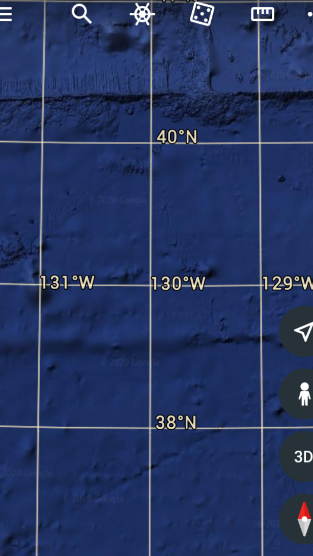 Photo from Google Earth is to the west of Cape Mendocino E-West reference at the Cape is an orthogonal reference- dominated by our Sun.
  Eocene includes the 39-40 million year Kenmei seamount reference:
  Miocene has up to 23 m.y. Age, and is about half of Eocene’s span. based on fossils, these ages relate nothing about Earth tides or Dynamics; what’s necessary is measure and calculate using Google Earth. Try your hand at using 20 km/million years to find anomalies which don’t fit this rate for the Pacific, and 17 for the Atlantic shift.
  Another anomaly is northwest of Hawaii, and has a CCW fan Rise surrounding a Clockwise sink; use the same technique that I used for Aleutians and 40 m.y. Kenmei.
  Marginal 5.9M jerk shows how ragged is the broken plate boundary:
 Figure from Google Earth has the impetus of Reverse Tides to the Cascades, which move eastward below the Inflection at 49N latitude (Canada’s eruption):
 Unsolved is the “hum” orVibration of Earth’s Crust; this includes LIBRATION-Rocking, and daily transfer of mass via Precipitation, ice melting, Basalt flows, and artificial hauling by man.
Apolaki crater offshore Philippines may be due to a strike, whereas the literature has it as an eruptive opening; my analyses have it influencing the N. Pacific basin, likely from a space mass- causing a bounce to another location, or from a splitting asteroid:

 Mars planet next door has Faults with no lateral displacement, parallel slices cast doubt on Earth’s “plate”surface- which hums and rotates, causing Polygons to appear, even on boulder-size rocks:


 Above is the Enigma of interest- the partly silted crater of unknown origin which reversed the Earth tides to the East to CA, OR, and WA. Instead of E-West transforms, there are diagonals \ offshore instead. 40N latitude is the main Reference, and sine= cosine 45 degrees is.707 for finding the reduced surface velocity at half of earth’s 180 degree hemisphere (90 degree pole has zero velocity, but 1 rotation daily of angular velocity).
11 is usually a Lucky number, so I expect another “roll of the Dice”:
 Kenai peninsula has Mesozoic with minor Paleozoic rocks, and it’s the start of the Aleutians archipelago; west part is active now, and may shed light on the crater-like large partly-silted figure bounded on the west by the N-South Emperor chain of seamounts older than 40 million years. Comparison with the upside-down similar figure near Cocos Island may help diagnose whether it’s a strike crater, and it’s shown below in 2 magnifications:
 Note that the linear portion is now to the south, but still north of the Equator. Some Siltation in grey occurs, and is an indication of the time since it occurred; overall it has the appearance of a strike- kicking up Cocos Island to the west, while Bering Sea has St. George to the east. Clues to this rare figure may stimulate readers to hunt for another one in the N. Hemisphere?
 Approach of an asteroid or Strike may determine the inverse appearance, since both figures occur in the N. Hemisphere. It’s likely more and more that a large diameter Strike has formed these craters!
 Above is a volcanic crater, for comparison with the Strike type. Needed is a photo of a Meteor crater such as occurs near the Mogollon rim in Arizona.
 South Georgia and Sandwich Archipelagoes are volcanic in origin, and have been classified as Reverse Tides by me; now, these are conjectured to have been formed by Strikes- appearing to go against normal west tides. These are in the Southern Ocean- connected to the Atlantic, as compared to the Cascades and Central America to the Pacific.
  Most Archipelagoes are volcanic, with exception of the Florida Keys; Japanese, Kurils, Marianas, and Antilles fit, but older- such as Papua and Philippines must be looked at more closely, since they have been affected by craters and subsequent events!
 Meteor Crater, near Williams, AZ, is a sink on the Mogollon rim; it is called Barringer, after the promoter who went to find metals; finding none, he augmented with astronauts training in a Moon crater- like training ground:
 Stoneman Lake is nearby- questioning the appearance of sinks on the Mogollon rim; it was searched by Dr. Beus to find that it’s a silted sink, in volcanic surroundings:
 Stone man Lake from literature is a sink (above), and not a volcanic- although several are in a Volcanic field near Flagstaff, Arizona. It’s a sinkhole, silted as far as measured, and cast doubt on others near the Mogollon rim! Below is another delight trekked by me - the Wave in the Paria canyon- not a sink, but an erosional feature in the Jurassic Navajo Jn sandstone:


Comments
Post a Comment