Posts

Showing posts from March, 2020

LaGrange Equilateral triangle on Earth’s crust

Image
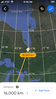
Finding that ET has a volcano at one corner and anomalies at the other 60,60 degree anomalies, I measured from Erebus, Antarctica 16,000 km north to Canada’s craton- Hudson Bay slice on the south side (see first Google Earth photo), James Bay- which is almost along a meridian and undistorted by a Mercator projection. Cratons of Canada and Australia are 16,000 km apart, but now not along a meridian 144 degrees apart, as at the start.  Australia’s craton “outback” above  has an anomaly shown, which seems to fit the curvature of an anomaly and subject to doubt, without further evidence. Now look at the angle made so far. It’s not 60 degrees, as found from other LaGrange triangles, but 120- which is 180-60: James Bay has Canada’s craton on the East side, and is 16,000 km from Mt. Erebus active eruption in December 2014; this line is nearly on a meridian, so that it’s approximately correct- unlike the line to craton center in Australia. Angle is not 60 degrees, but closer to 120(se

Development of the Colorado plateau Cp after Rocky Mountains

Image
Colorado plateau Cp is best seen at the  Having found that the deepest Sink at the Dead Sea is 777 km from Tuz Golu, Turkey- forming an equilateral triangle with an eruption in the east, I searched Death Valley, Badwater (next lowest in USA), and it forms an ET with an eruption at the Mexico border (shown below) and the intersection of the Colorado and little Colorado Rivers. Expected error occurs because 2D Google Earth has no 3D in a Mercator projection map. Ratio of 555/666 km for Colorado plateau Cp makes this plot older than Cp of 41 million years. 40,000/360 degrees= 111.11 km/degree in all directions, regardless of Earth’s spin and tilt. Hurricane fault Hf, since the Slickensides seen at Hiway 9 near Laverkin, Utah show the fall of the Basin and Range \ to the west, and the CounterClockwise CCW of the Cp some 1-2 mm/year- due to gravity resistance. East side is complex, due to the Cimarron Mountains being East of the Sangre de Cristo (Christ’s blood)- where the Paleocene