LaGrange Equilateral triangle on Earth’s crust
 Finding that ET has a volcano at one corner and anomalies at the other 60,60 degree anomalies, I measured from Erebus, Antarctica 16,000 km north to Canada’s craton- Hudson Bay slice on the south side (see first Google Earth photo), James Bay- which is almost along a meridian and undistorted by a Mercator projection. Cratons of Canada and Australia are 16,000 km apart, but now not along a meridian 144 degrees apart, as at the start.
  Australia’s craton “outback” above has an anomaly shown, which seems to fit the curvature of an anomaly and subject to doubt, without further evidence. Now look at the angle made so far. It’s not 60 degrees, as found from other LaGrange triangles, but 120- which is 180-60:
James Bay has Canada’s craton on the East side, and is 16,000 km from Mt. Erebus active eruption in December 2014; this line is nearly on a meridian, so that it’s approximately correct- unlike the line to craton center in Australia. Angle is not 60 degrees, but closer to 120(see yellow lines for true angle).

 Continuing on the equilateral triangle which will have Crater Lake 444 km from Lake Tahoe sink, note the small jerk at Truckee River- just east of Lake Tahoe,444 km to Crater lake volcano. This 7,700 year rise has Wizard Island as a resurgent dome. Go to next frame for Google Earth photo.
  Heat from Mt. Mazama and the 7700 year eruption is the hot corner of a 444 km Equilateral triangle, which is older and providing use of 40,000/360 degrees globe diameter = 111.111 km/degree in all directions. Find oldest eruption of Mazama.
  Literature age of Mazama 400,000 years is likely a guess, with only 1 significant figure, and it’s less than the million for Nimrud in Turkey’s minimum for 777 km separation. Inverse proportionality may be incorrect! Mendocino Transform is one anomalous corner, and offshore segment may be measured for the Time interval since moving 20 mm/year.
 Algorithms (Al Gore rhythm) have “homed in on me” from England, so that a rock Triangle (the Eternal infernal) popped up, like a barking pup, and I saved it- since I am enamored of all types!
LaGrange solved Mathematically the triangular arrangement of Space masses, and I have applied the Equilateral triangle in Earth’s crust for 3 corners of 69,60,60 degrees separately from the mantle- since it moves independently at anomalous events: strike and volcanic Craters being most easily found, among surface mysteries. Cases are found for both, and multiples of 111 km will be shown:
 Since Magna, Utah has a 5.7M jerk at 7:09 today March 18/2020, I found Twin Peaks in the neighborhood and extended 444 km to Lake Yellowstone crater, and made an equilateral triangle back to Twin Peaks-34 km from a total of 3 x 444=1332. Since 40,000 km circumference divided by Earth’s 360 degrees is 111.111 km/degree along a meridian, then total should be 4 x 111.111= 444.444, taking 1,366/3=455.3, and reducing the displacement slightly.
 March 18/2020 jerks and aftershocks are shown, with the first at 5.7M for Magna, near Salt Lake City continue with no deaths so far. Searching for an equilateral triangle to the west, I found that Mt. Lassen was 666 km from the anomalous Columbia-Snake junction near Kinnewick, Washington. It’s 666 km from the Geothermal area near Hiway 15, south of the Snake. Completed equilateral triangle is shown below, with 2,057/3=686 km and 20 km err:
 Jerks associated with the Conjunction of Gibbous Moon, Jupiter, Mars, and Saturn produced a 6.3M today-18 March 2020, and I am busy to find what strikes next, so I will start at Virgin River’s Dixie springs near the Hurricane fault Hf, and I found that Mt. Taylor is 555 km away, Uinta Mt. Forerunner at 1,110, and back to Hf for an Equilateral triangle at the perimeter of 1640 km/3=546 km, with displacement of 9 km. Recall 40,000/360 degrees = 111.111 km/degree, and cases show that it works in all directions- not just between latitude degrees:
 Latitude Reference on the West coast is Mendocino transform 40.439N- shown at left- where an”S”, meaning rising of the seafloor. Although 40-41 million years of age, it’s still moving west at 20 mm/year- allowing age to be calculated from the distance from the coast.
  Finding that Mt. Rainier is still active, I found that it influences Orcas Island away 222 km, as shown by the channel- moving Northwest with time and erosion. 647 km is in error by 222 x 3= 666 km-647= 19, or 3 percent, acceptable to Engineers, compared to Geologists’ 20-30 percent.
 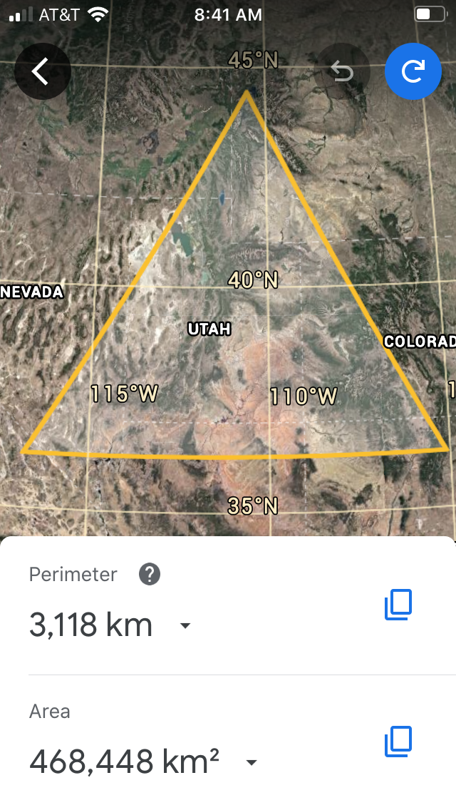 Yellowstone geysers and underlying heat have geologists’anticipation that an eruption is pending, so I intend to find if it fits the LaGrange equilateral triangle at multiples of 111.111 km- the ratio of circumference/360 degrees. Dreaded Uplift might fit the greatest sink in the W. Hemisphere- Death Valley. Separation is 1,039 km- a third of the perimeter shown. Although the southeast corner fits the edge of the Colorado plateau Cp, there is no great edge anomaly there! Conclusions are that there’s no multiple of 111.111 km, there’s no affiliation with the Heat of Yellowstone and sinking of Death Valley, even though the ET contains most of Cp, there’s no threat of a Yellowstone catastrophe, and it defies my analyses!
 Measuring further away, Yucatan’s Chixculub 64 million years ago was active, and it’s 3,333 km distant (above), but not agreeable with the oldest rock at Yellowstone (2.1 m.y.)30 to 1 ratio! Further, the Northeast corner has no anomaly to classify (Paleozoic or older). SW side has the only information of value:64 million and it fits the LaGrange equilateral 3333 km side (9993/3= 3,331km, with insignificant displacement.
 I tried the worst New Madrid catastrophes at 1811-12 at the Mississippi River and it was excluded!
 Yellowstone’s Heat continues, and it has erupted twice in the last two million years; it’s separated from 64 m.y. Chixculub by 23 degrees of latitude, and has 1,000/9= 111.111 km/degree. Cases have shown that 3,333/111.1= 30 degrees, regardless of orientation. Mercator maps and Google Earth present 2D, and 3Dimension is necessary for accuracy- particularly at latitudes over 45N; 30 degrees (a Ratio, without dimensions) at 111.11/degree yields 30- the ratio of 64 Chixculub to Yellowstone 2.13 m.y. I have to confirm that 3,333 km extends in all directions, and that the Northeast corner of North USA has a Dynamic anomaly. St. Lawrence Seaway is such and borders on static Canada’s Craton- which is Pc and has remained so since Cambrian time!
 St. Lawrence Seaway separates Maine, USA, from the Craton orange Pc and red older eroded granites and greenstones; no dynamics except erosion occurs there. Conversely on the USA side there are younger and actively-moving Paleozoic rocks.
 Not satisfied with the preceding section of the Yellowstone geysers to Chixculub at all, because of the 64 million years age, lack of dynamics at the NE USA St. Lawrence Seaway, and Chixculub location being vague, I found that the Grand Canyon SINK is the greatest anomaly in the possible N. America’s options. Radius of 999.99 km fits the 9 x 111.11 km/degree = 1,000/9 scenario. Photo of the Southeast corner has 3,022 km total for the Equilateral triangle, and dividing by 3 yields 1,007 for the side length. Yellowstone to Colorado River left turn to Sierra Grande dormant volcano in NW New Mexico, and back to Yellowstone geyser should be 3 x 999.99 km= 3,000 km within 1 kilometer. I will re-plot to show other corners:
 Bingo! I re-measured and got within 3,034-3,022= 12 km for the total perimeter;.4 percent variation, due to slight distances on Google Earth measuring tool, and my hand “jiggling”! This now confirms that Yellowstone Heat is due to transfer of mass (silt to rocks) down the Colorado River, erosion of Capulin and Sierra Grande craters, and the annual shift of the Equilateral triangle at multiples or fractions of 111.111 km/degree (90/hemisphere) of ET!
 Southeast corner is near Capulin and Sierra Grande craters, as seen on left photo. Now a happy face, for finding that Yellowstone is failing to erupt- so long as Lake Powell and Mead hold the silt and rocks, and prevent mass from transferring to Mexico’s Bay to Cabo San Lucas. Mass is held until one of the dams break- as almost happened with the deluge 10 years ago!
 Triangle has 3 sides of 111.1km each; perimeter is 3x the side. Since I lived on Whidbey Island, WA for 18 years, I hiked all the beaches- where my wife was in a group: “Ladies of the beach”, and I led another group: Sons of the Beach, I wondered about the many sinks and mounds. Today:March 20th of 2020, I made an equilateral triangle ET from Mt. Olympus- the cause of our rain shadow- 111.11 km on a side, to encapsulate the entire island as shown. Hope was to find what made the protected sinks, and how they’re related to nearby mounds. ET doesn’t solve that mystery, but you can enlarge the photos to analyze and forward your conclusions?
 Yellow line is the side of ET, and accentuates the low area with prolific vegetation; look for anomalies along sides, but especially at ET corners:


 Sand line is shown via Google Earth for an unknown time. I have chosen this duo, since I have hiked it many times- finding a Black Hole in the creekbed for a photo shown later. “Little picture” is chosen to find if LaGrange equilateral triangle works for small features.
Conclusions:1. LaGrange ET works on small triangles
2. Anomalies fit the corners for Zion and Sand Hollow.
3. Orientation of triangles isn’t important; and
4. Mercator 2D is similar to 3D at small separations.
Returning to the Yellowstone geysers and 999 km to the Colorado River abrupt change in its path below Lake Mead, Arizona, I proceeded to Oregon’s corner at 1998 km which at 3,012/3= 1,004 km sides, and.5 percent deviation from a side. Two equilateral triangles make a diamond-shaped polygon shown for crystalline shapes below:


Comments
Post a Comment