Development of the Colorado plateau Cp after Rocky Mountains
 Colorado plateau Cp is best seen at the

Inselberg or Monadnock is the term used for remnants of upright resistant rock, and I will add a photo- other than Texas granite mound shown:


 Cimmaron canyon and Mountains are to the east of Rocky-Sangre de Cristo, and younger as shown in Paleocene Poison Canyon in the outcrops; bifurcation of N-South ranges adds error to the analysis, so measure on the Wasatch line on the west side.
 Still in the east side, and Wasatch line to Hurricane fault Hf is next:

 Primary uplift of Cp is the PreCambrian monadnock Uncompagre 1.9 billion years age; it’s the center of Cp and rose via expansion above Earth’s mantle some 50-80 million years ago in 3 stages. Last occurs with extrusions at Jemez Volcano, NM, and Yellowstone within the last million years, and can be seen at the Hf Arizona border- called the Divide. Find the first Jemez eruption Age.
  Cp is shown, with Uncompagre peak at 38N 108W approximately:
 Mistake in path for the half ellipse, and you can scribe your path- using the IPad measuring tool, for the Google Earth photo below:
 Why would an elliptical path of craters be followed? Earth’s crust took a reversal 1-2 million years ago, and the m.y. Time marker has quarters:250,000,62,500, 15,625 years ago at the last “Crust’s mass-land shift” as seen on Whidbey Island’s Penn Cove west orientation. Regularity of 64 million Chixculub, 16 Columbia flood basalts, 4 m.y. Philippines largest Crater, 1 million- continuing to 3,906.25 years ago Greek debacles or Santorini killer (1810 BC-3830 years ago.
  If the Coronavirus “takes the Oxygen our of the room”- do some Mooning (showing your buttocks out the car window) with aplomb!
 3 eruptions today-2 days after the Full Moon- when microcracks open to form exit Fractures. None at dormant cones at Hurricane, Utah- whistling wind of March instead- then April showers bring May flowers!
 Santorini history has “beware of Greeks bearing gifts”, and forget not the Ides of March-15th.
  Jemez (Spanish James) Caldera is now a National monument, and there are stinking Jemez hot springs, shrieking Mountain Lions- which I heard- and the Las Alamos “hot dry rock” failure to enthrall you. Dr Al Blair traipsed around the SW, to find other prospects for Geothermal power Gt. Oh, for the “daze of yesteryear”!
 Large view shows that the 3 divisions are Arcs which have expanded to the south- in Arizona, along the Mogollon rim; this is interspersed with the San Francisco peaks at Flagstaff, and the 1045AD crater on the NE side is the latest to erupt. All types of eruptions have occurred: basalt, high-viscosity silicic flows, blasts, and phreatic ashes.
  Mogollon rim is a 320 km side of the Cp, and1/125th of Earth’s circumference; tracing NW-SE, it would be the side of an Octagon of perimeter 2,560 km, if regular. Find the Geographical perimeter, since it’s irregular with several arcs.
  Measuring with IPad intervals, perimeter was 2,267 km and shy because I used a 7-cornered polygon.
  Measuring more carefully, I found 2561 perimeter, and its north border of the Hexagon is at the Uinta Mountains; this cuts off the more vague portion involving the Yellowstone Geothermal corner! Jemez caldera is kept as the SE corner.
Re-measured on the IPad yields an irregular 10 sidedpolygon of 2,556 km perimeter; corners are from my memory, of hikes and photos made in my work with Dr. Al. Blair of Las Alamos National lab, mostly on the east, south and west side- where I now live. Trip from Durango to Telluride by train goes near Uncompagre Peak, and is a climb to the highest elevation Inselberg or Monadnock- which must be determined for impetus. Although 1.9 billion years of age, it rose 50-80 million years ago. Rise preceded Cp formation, and it’s not volcanic but base of Earth’s crust. Peak is not at the center of Cp, but to the east- possibly yielding a distance ratio of x/80- to find x as Cp uplift start.
 Cp has a lot of Radioactive elements which have been found in petrified wood and with Petroleum production; hence I am speculating that the base of Earth’s crust expanded due to radioactive heat in all directions- creating a bulge along which the mantle slid past. This shoved the Heat-induced bulge during the half-lives of K, Th, and Uranium upward in the 1.9 billion years age Uncompagre uplift gradually. Measure the fraction of E-West width that’s Uncompahgre position to determine when Cp started uplifting.
Uncompahgre data from literature have location and elevation to place it 244/753 km= .324 fraction of 50-80 million years, or 25.9 m.y. Rate of Earth tides to get 41 million is 15.06 mm/year, and is lower than average because of the lower viscosity of the heated portion of the crust. Rate depends on the width selected of the irregular Cp. Parallelogram has constant width, bur Cp is polygon-shaped!

 Geographic map of the San Juan Mountains which have the monadnock Uncomprahgre Peak shown, and decimal coordinates in the preceding frame.
 West edge of the Cp has Cedar breaks and Zion National Parks has great literature; shown is the cross-section of outcrops, which have Permian Kaibab limestone to Tertiary sedimentary outcrops, and petrified wood to identity it. Youngest basalts lie over Paleocene redbeds at Hf Cedar breaks 14,000 feet for a difference in elevation- due to less erosion-2000 meters. Incline is 2 km/80 km=1/40, or 2.5 percent.

 Geologists cross-section- profile looks at a Vertical view of Formations, regardless of slope of the column; Zion is raised, but not as much as Cedar Breaks- where the youngest surviving erosion is Paleocene, except for resistant Pleistocene BASALTS, next is a graph with coordinates of space masses, for the distribution relative to Earth’s Tilt of 23.439 degrees:
 With significant scatter, the 23.439 degrees tilt angle has the largest contribution to the plot.
  Measuring with my IPad yields longer polygon sides, so use the 3.4 mm/year uplift Rate or less Earth Tides rate for anomalous features such as Hf, and check the Eruptions ellipse less than one million years surrounding the Hurricane City basalt eruptions: Sullivan knoll, Water tower, and Red ash crater.
  Today- Friday 13th is unlucky for the Souls at Ebeko and others who have Coronavirus and Eruptions 13 days away!
 Sunset crater of 1085 AD age is in the Flagstaff, AZ Volcanic field, and shows that this system off the Mogollon rim is still active!
 Jemez literature has it at 40,000 years ago, after initially at 14 million years; Bandelier tuff is seen around Las Alamos, NM, and paleoIndians have worn meter-deep trails through it. Age puts a lower limit to the Cp southeast corner, and a third of the age of the rising plateau (14 x 3= 42 m.y.). Why a third; triangles are the simplest polygons, and it’s 2/3rd of the corners until Flagstaff’s Mogollon rim.
 Mt. Taylor is on the south edge of Cp, and young flows have crossed I-40 freeway; it’s 29 km southeast of Ambrosia Lake pitchblende UO2 deposit- now abandoned for cleanup. Using literature approximations, the Rate of Earth tides movement is 15.333 mm/year for the edge of the Colorado plateau Cp. Expected is that radioactive compounds have risen with Mt. Taylor since 1.5 million years ago, but this is just for the edge moving southward, and I must find the fraction of the distance from the Uncompahgre oldest uplift.
  Ore found at Ambrosia was pitchblende shown in literature above and below photo:

 Sierra Grande is a million year old extinct volcano which is extinct and to the east of Capulin 60,000 years crater. Rate of 11.9 km/.94 million yields 12.66 mm/year for the east outside of Cp. This anomaly is north of Jemez crater of 14 m.y. age.
 Capulin in north New Mexico is a 60,000 year extinct crater, and east of the Cp- indicating Reverse Tides, calculated to be 12.66 mm/year there;1 million Sierra Grande is east of it- showing that Earth tides are now back to the west. Interlude of Cimarron Mt and Creek disrupted the Cp sequence expansion.
  Stoneman lake on the Mogollon rim is 60,000 years old by my calculations, as is its nearby Barringer-Meteor crater, created by an asteroid from space. Capulin defunct volcano is of Same age- having risen to offset the sinking of Barringer and Lake Stoneman. All 3 are outside of Cp, and have disrupted its expansion. West Cp now expands to the west at intervals, as seen at the Washington City fault with 78F springs’ water flowing under I-15 freeway in WC!
 Meteor crater is open to the public, and served as a training ground for astronauts planning to encounter our Moon craters.
  Warm 70F+ at Washington City I-15 freeway was found “in the clouds” merely by searching Porogle boiler,7 years ago I measured it and Google search has retained it!
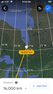
 Mystery introduced now is the 666 km separation of Meteor-Barringer crater near Flagstaff, AZ, but not on Cp, and the NM Capulin volcanic crater of the same 60,000 years Age. Barringer is 666 km from the Uintas’ bifurcation East of Salt Lake City, on Cp- which is PreCambrian and the Focus of the California coast arc (< later eighth. Measure this distance to find its Age by dividing by 20 mm/year. Triangle with 666 km sides is a LaGrange equilateral with one corner Hot (Capulin uplift from Meteor sink of same age), but because of the 2D Mercator projection for a 3D feature, the third side is 745 km to Capulin (79 extra), and an expected err. Pc Uintas has guided the meteor to its AZ landing, and is not the highest elevation on Cp; this mystery will be explored further on the Anatolia plateau Ap.
 Measurement of the Focus distance to the Uintas’ Focus is 1068 which divided by 20 mm/year is 534 million years Cambrian, although argumentative. Coast has extended to the SW continuously since Pc time, and seems reasonable. Process will be checked using younger Anatolia, even though it’s orthogonal at 90 degree orientation to Cp.
  Photos show theLaGrange equilateral triangle in space- where the size may increase while the shape remains 60,60,60 degrees at corners, and I presume that this applies to 3D earth’s surface. Error is involved when a curved surface doesn’t allow the triangle to close out. Experimenting, I will continue, experimenting with Anatolia Turkey plateau Ap.
 I have visited Pamukkale (Cotton castle)- working on Denizli geothermal well Kizildere in 1972. Hot corner goes back to Roman times and earlier. Searching from that heat, I will find a young crater from a strike, for comparison.
  Nemrud (King Nimrod) is a million year age eruption in East Turkey, and last erupted 347 years ago; plot coordinates to find a LaGrange equilateral triangle to a sink crater:
 Nimrud leads to Tuz Golu 777 km to the west, and the age will be6/ 6/7 x 42= 36 million years Eocene. Third side of the LaGrange 60,60,60 degree triangle will be across the Mediterranean in Israel (anomaly on the Dead Sea).

 Tuz Golu is shown, and it appears that ionization of brine is involved; clue is that Electric-Magnetism exerts its influence on Earth’s crust. Voltages can be measured in boreholes on the Spontaneous Potential SP Curve (100 mv) due to moving brine through porous rocks, and the limestones may be less influential with larger cations of Ca and Mg.

Comments
Post a Comment