Earth’s crust’s Extremes: Deepest, Highest, coldest, hottest, fastest, and bizarre:
 Path is established at perimeter:20,134/3=6,711- a measuring error of 45 km (.67 percent) due to Mercator projection (2D rather than polar coordinates with 3 dimensions). Mariana’s Guam north of the Deep at 6,666 km.
  Starting with Mauna Loa- the tallest volcano above the ocean floor- proceed to the Challenger deep, greater than 10 km trench, stretch 6,666 km to its depth. Anomalous- it is 13,332 km (twice as far) to the fastest-moving Kermadec trench near New Zealand.
  Center of the Triangle is at Roreti- rotating half circle between Pacific’s Time shifts at 2.7S 176.8E longitude, above.
  Kermadec trench- fastest in the known observed globe- is near New Zealand, lies on the corner before completing the Triangle to Mauna Loa, above.
Now for the hottest Erta Ale crater and the deepest Dead Sea sink- where 2,222 km is the 20 degree spacing between the two anomalies above and below:


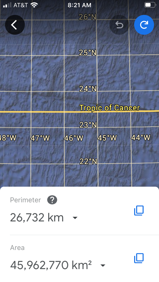
 Tropic of Cancer has appeared for the long distance anomalies, and it’s the latitude where our Sun is at the northern-most overhead location, and is an inflection of unknown importance! 23.439 degrees varies with time and the location will, also.
Introducing the effects of a Strike, forming a 210 m.y. Crater in Quebec- shown below:
 Denali peak leads to a crater in East Canada- where it may be the strike which started the uplift of the volcano; search for the age of this strike, to tell which came first:


Introducing the highest elevation on land:Mt Everest, I measured this twice, so that you can see the error of repetition, below are the two measurements with 109 km difference, or errors of 2 percent:


 Location of Mt. Everest from the literature.


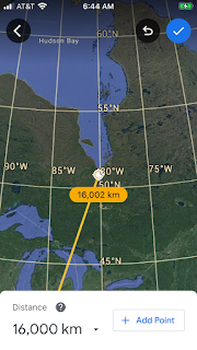
4,554 km side has110(2.5 percent) km error- which occurs when the high Latitude makes an arc; it’s near Cordova,Alaska where the great killer quake of 1964 occurred. Dynamics of the expanding ET with time would produce another at an unknown time (20 mm/year).


2. Mt. Charleston rise is the hot corner, with uplift and springs;
3. Nevada mountains and basalt flows rise, to offset sinks at the 2 corners; and
4. Low density salts are offset by high density basalt; and
5. Dark energy puts Geometrical and Gravitational mass together, to make Equilateral Triangles solve the Dynamic Earth tides that categorization by the Geo culture is unable to understand.


 Now to an anomaly in the Pacific NE
NW of Hawaii, which appears to be the 39-40 million year strike which caused the Emperor chain to move to the southeast. In addition, it reversed subsea Bowlers Ridge, as shown above. Below is the west arc of the anomaly:


 Dark energy may be the factor which adds to Geometry’s LaGrange equilateral triangles and Gravitational mass attraction to form these polygons on the Earth’s surface and Crust.
Conclusions for Galapagos and ICELAND’s triangle analyses:
1. Correspondence of my expected affiliation is weak;
2. Age of 16 million years for rise above sea level of Iceland’s NW corner must be compared with Galapagos’s, since Wolf is a recent eruption;
3. Both Equatorial Wolf and Iceland’s locations are singular (1 only), and anomalous;
4. Volcanic islands at the MAR are rare and near the ET, and ages should be found from literature; and 5. Mercator map in 2D yields increasing departures at high latitudes- measure only below the TOC!


Comments
Post a Comment