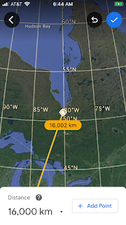
Hawaii’s Mauna Loa has a Crust component with the Challenger deep 6,660 km away

Marianas Trench is long and arcuate, and the Challenger deep is shown above for coordinates, and below is Mauna Loa 6,660 km away (60 x 111 km):


Hawaii’s quake July 3/2020 reminded me that the two track basaltic vulcanism has two impetuses in the young archipelago:


Continuing at multiples of 111 km from Mauna Loa, the subsurface seamounts are mostly spaced at multiples of 111, until Midway and not older!

Below is the last seamount which fits the 1,998 km (which’s 111x 18), and the start of the 2 track past Midway Island- which is shown below ow:

 Above inflection and rise-remnant represents a location and age where uplift has remained, and the age may be found in the literature:
Oligocene is near the 28 millions GE, and the literature is shown below; shift of Midway must be to the west to have Spain’s impact be the impetus. 


What then is the source of the moving eruption except for the “mantle plumes”?
Clues are found with the finding that Midway Island doesn’t fit the 111 km multiples and has risen due to a strike described previously; 1,998 km the last (111 x 18; 


 Contribution by yours truly will be to”tip my maple leaf cap” to Puget Sound (nearby), and find the source of Hawaii’s basalt flows for other than assertions of mantle plumes, radioactivity, and hotspots. Southeast progression of the double track from Midway Island, and transformation from Kauai to the Big Island to an archipelago are important clues since 28 million years ago. Aleutian Archipelago is moving south, and the bind of 45 degrees is heating blasts at Alaska, while Hawaii is getting slow basalt flows!

6591/3= 2,197 km, for 23 km deviation (1 percent from perfect), and ET is shown below:


No heat is derived from radioactive uranium as is pitchblende at Mt Taylor, New Mexico (near Gallup), but is generated by an inflection at the Mendocino transform termination. Shift there correlates with formation of an archipelago from Kauai to the big island of Hawaii:
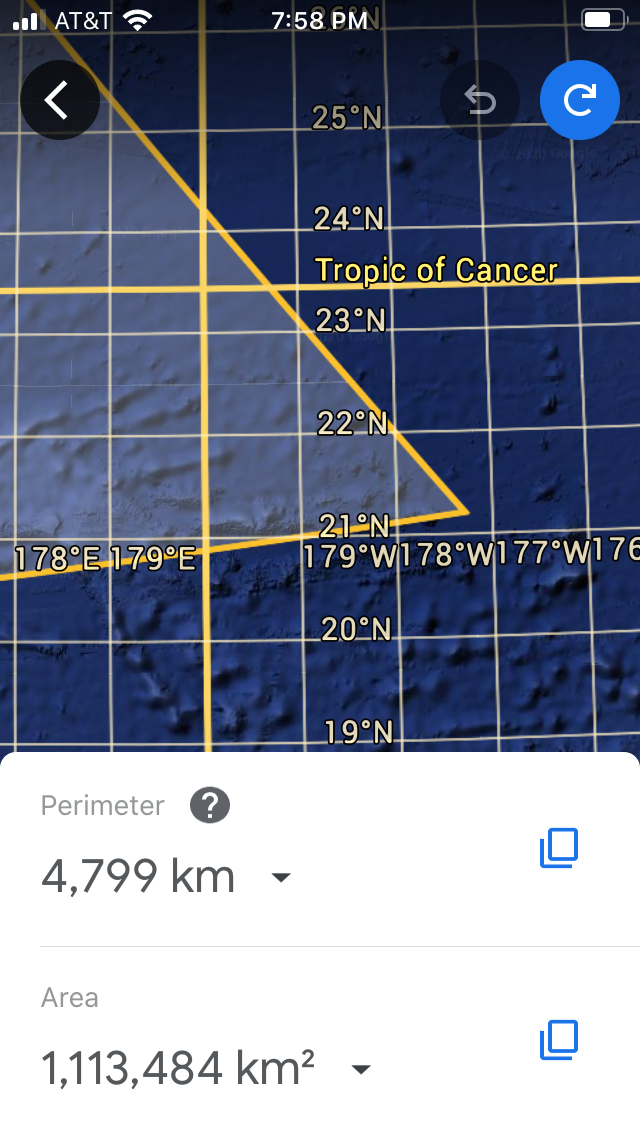
ET shown overlaps the Tropic of Cancer,
Shy of Midway Island is 2,220 km-sided feature which’s 20 x111, and fits the global units for important anomalies such as pertains to the vulcanism in the Emperor chain, in this case where Midway is in another sequence and south of that the energy derives from the slice west of the Mendocino transform. Equilateral triangle for the 2,220 km sides is shown below:


 Conclusions are 1. Crust transmits energy-Heat independent of the mantle for uplifts of the Emperor chain;
2. Basalt extrusions- such as Mauna Loa- are younger, and belong to a Pliocene to Recent archipelago;
3. Midway belongs to a separate system, and older seamounts also;
4. South side of Mendocino transform slices westward and creates heat at Hawaii in so doing; and
5. Double track of uplifts starts after 28 million year Midway, and was created by a strike then.


Wake Island is explored next, for the connection with the 40 million year old Kemei seamount:


Note the splash location from the Philippines crater Analaki is above and below;

East turn in the Emperor chain is below and Wake is involved in its shift: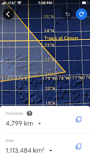
Bowers Ridge is shown to get another connection with the Mendocino transform:


Reversal of Bowers ridge seems to be of the same 39-40 million years age as the bend in the Emperor chain, so let’s measure it towards the south, using the 111 km multiples as a localizer. Below is a literature photo

Rat island, Aleutians is the start below Bowers ridge- shown below: 

Southeast corner lies on the Mendocino transform at its western extremity:

Above is the roundabout connection of Bowers,Hawaiian archipelago, and the Mendocino transform. I speculate that the transform shears right-lateral producingHeat for the present Hawaiian eruptions:


Comments
Post a Comment